The Grand Duchy of Luxembourg (Gutland)
August 08, 2025

Grumelange, Luxembourg, België / Belgique / Belgien
Easy
Description

No description for now...
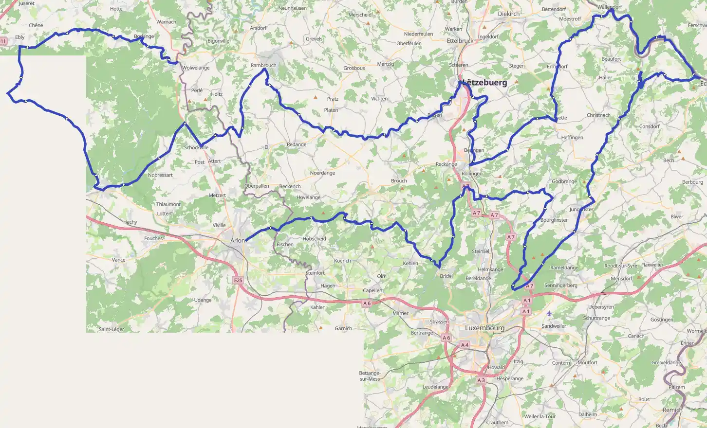
Route
Start
280 m
Rue de l'Eglise
49.82747, 5.74387Rue de l'Eglise
RouteYou Climb Code : D_1_c
- Length : 0.65 km
- Ascent : 64 m
- Average grade : 10 m / 100 m - 9.72 %
- Maximal grade : 13.67 %
Author: Cols&Climbs@RouteYou
More information
1.22 km
Rue de la Harot
49.83508, 5.73430Rue de la Harot
RouteYou Climb Code : E_2_b
- Length : 0.6 km
- Ascent : 48 m
- Average grade : 7 m / 100 m - 6.71 %
- Maximal grade : 17.41 %
Author: Cols&Climbs@RouteYou
More information
8.04 km
Fauvillers
49.85046, 5.66694Sculpture on an old tombstone monument of the Sacré Coeur church cemetery.
Author: Dromos
More information
24.71 km
Léglise
49.80111, 5.53944On 1 January 2007 the municipality, had 4,178 inhabitants, giving a population density of 24.2 inhabitants per km².
Author: Wikipedia
More information
37.99 km
Habay
49.72944, 5.64694On 1 January 2007 the municipality, which covers 103.64 km2, had 7,903 inhabitants, giving a population density of 76.3 inhabitants per km2.The municipality consists of the following districts: Anlier, Habay-la-Neuve , Habay-la-Vieille, Hachy, Houdemont, and Rulles. Other population centers include: Harinsart, Marbehan, Nantimont, and Orsainfaing.
Author: Wikipedia
More information
55.73 km
Colpach-Haut
49.76667, 5.81667Colpach-Haut is a village in the commune of Ell, in western Luxembourg. As of 2001, the village has a population of 144.
Author: Wikipedia
More information
58.37 km
Roodt
49.79306, 5.82167Roodt is a small town in the commune of Ell, in western Luxembourg. As of 2005, the town has a population of 150. Longitude : 5.82 Latitude : 49.79 Altitude : 428m
Author: Wikipedia
More information
65.31 km
Folschette
49.81667, 5.86667Folschette is a small town in the commune of Rambrouch, in western Luxembourg. As of 2005, the town has a population of 273.
Folschette was a commune in the canton of Redange until 1 January 1979, when it was merged with the communes of Arsdorf, Bigonville, and Perlé to form the new commune of Rambrouch. The law creating Rambrouch was passed on 27 July 1978.
Author: Wikipedia
More information
65.31 km
Hostert
49.81667, 5.86667Hostert is a small town in the commune of Rambrouch, in western Luxembourg. As of 2005, the town has a population of 341.
Author: Wikipedia
More information
77.07 km
Useldange
49.76866, 5.98031As of 2021, the town of Useldange, which lies in the east of the commune, has a population of 1965. Other towns within the commune include Everlange, Rippweiler, and Schandel.Useldange Castle is a medieval castle, which, while now being mainly in ruin, also comprises the current town hall. It is located in the centre of the village, right opposite to the town's church building. The site can be visited throughout the year with special arrangements for poorly sighted visitors. It is also the location for the annual medieval festival in Luxembourg.
Author: Wikipedia
More information
93.17 km
Cruchten
49.80082, 6.13494Cruchten is a small village in the commune of Nommern, in central Luxembourg. The village has a population of 679.
Author: Wikipedia
More information
98.10 km
Pettingen
49.76667, 6.11667Pettingen is a village in the commune of Mersch, in central Luxembourg. In 2005, the village had a population of 198.
Pettingen Castle in the centre of the village is one of the best preserved fortified castles in the country.
Author: Wikipedia
More information
99.22 km
Beringen
49.75919, 6.11997Beringen is a small town in the commune of Mersch, in central Luxembourg. As of 2001, the town had a population of 930. It is situated approximately 16 km from the capital city of Luxembourg, as the crow flies.
Perhaps the earliest written mention of Beringen is in a deed of gift from Erkanfridas, the widow of a minor nobleman. It was written in 853, and mentions a forest in Beringen which was to become the property of the abbey of St. Maximin.
Author: Wikipedia
More information
108.52 km
Larochette
49.78654, 6.19940There is something strange about the village of Larochette in Luxembourgh. The square is a platform for debate and story telling. A scene you rather expect to see in more southern countries, but not here! The explanation? Half of the population is coming from Portugal or Cabo Verde.
Author: Dromos
More information
109.96 km
Larochette Castle
49.78555, 6.21681Larochette Castle stands high above the town of Larochette in central Luxembourg. Dating from the 11th century, the castle was destroyed by fire at the end of the 16th century. Since its acquisition by the State of Luxembourg in 1979, some restoration work has been undertaken.
The castle ruins are located on a promontory some 150 metres above the White Ernz which runs through the small town of Larochette. The access road crosses a large farmyard with fortified earthworks. The main building is surrounded by a wall, now partly destroyed. A deep ditch divides the castle into two parts. At the far end of the promontory, the remains of several manor houses attest to the high quality of the architecture and its rather pompous style.
Author: Wikipedia
More information
123.93 km
Our
49.87511, 6.28667The Our is a river in Belgium, Luxembourg and Germany. It is a left-hand tributary of the river Sauer/Sûre. Its total length is 78 kilometres .
The source of the Our is in the High Fens in south-eastern Belgium, near Manderfeld. It flows southwards, more or less along the German-Belgian border, and after Ouren, along the German-Luxembourg border. The historic town of Vianden lies on the Our. The Our empties into the Sauer in Wallendorf.
Author: Wikipedia
More information
124.09 km
Wallendorf-Pont
49.87389, 6.28945Wallendorf-Pont is a village in the commune of Reisdorf, in eastern Luxembourg. As of 2001, the town has a population of 83.
It is located on the Sauer river, on the border with Germany. It is connected to the German town of Wallendorf by a bridge.
Author: Wikipedia
More information
124.29 km
Wallendorf
49.87944, 6.28944Wallendorf was first mentioned in an old document from 1136 as "Vualcheresdorf". It is located on the German side of a bridge connecting it to the Luxembourgish town of Wallendorf-Pont. The bridge was of strategic importance during the Battle of the Bulge in World War II.
Author: Wikipedia
More information
133.83 km
Bollendorf
49.85306, 6.36167Bollendorf is a German municipality in the state of Rhineland-Palatinate, located on the left bank of the Sauer river, opposite the Luxembourgish town of Bollendorf-Pont.
Author: Wikipedia
More information
143.29 km
Berdorf
49.82105, 6.34906Berdorf is a commune and small town in eastern Luxembourg. It is part of the canton of Echternach, which is part of the district of Grevenmacher. Berdorf is known for the sandstone rocks surrounding it.
As of 2014, the town of Berdorf, which lies in the centre of the commune, has a population of 1,853. Other towns within the commune include Bollendorf-Pont, Grundhof, and Weilerbach.
Author: Wikipedia
More information
151.57 km
Müllerthal
49.78969, 6.30686Dit Müllerthal wordt gekenmerkt door de meest bizarre rotsformaties. Ze kwamen na de laatste ijstijd tot stand. Ontzaglijke hoeveelheden smeltwater moesten zich toen een weg zien te banen door de vaak smalle valleien. Klei en andere grondsoorten spoelden daardoor weg, en de onderliggende, zachtere zandsteen kwam bloot te liggen. Die ging door de eeuwenlange inwerking van regen en wind allerlei grillige vormen aannemen, wat tot vandaag voor een fabelachtig schouwspel zorgt.
Niet voor niets wordt de streek ook La Petite Suisse' of Klein Zwitserland' genoemd.
De rotsen zelf luisteren naar namen als Arendsnest, Preekstoel en Perenkop. Bij zonsondergang lijkt het wel of La Petite Suisse is bevolkt met de schaduwen van gedrochten en geheimzinnige dieren.
Het dorp Müllerthal zelf is piepklein: Het kan er intussen wel eentje meer of minder zijn, maar volgens recente cijfers wonen in Müllerthal niet meer dan 45 mensen. Zoals gezegd is Müllerthal is meer dan een dorp, het is ook de naam van het dal waardoor de Ernz Noire stroomt.
Author: gilbert5
More information
152.48 km
161.85 km
Junglinster Longwave Transmitter
49.71853, 6.26083The Junglinster Longwave Transmitter is a longwave broadcasting facility used by RTL near Junglinster, Luxembourg, which went into service in 1932. Its aerial consists of three free-standing steel-framework towers, which are ground fed radiators. These towers formed a directional aerial for the frequency 234 kHz and until 1980 were 250 metres high. Since 1980 their height has been 215 metres.
Author: Wikipedia
More information
162.86 km
Junglinster
49.71111, 6.25139Junglinster is a commune in central Luxembourg, which draws its name from its principal town, Junglinster. It is one of six communes in the Luxembourg canton of Grevenmacher. The 18th-century St Martin's church is a national monument.
The oldest mention of Lincera is in documents going back to 983, with the status of parish first attested in 1128.
Author: Wikipedia
More information
180.49 km
Gutland
49.70000, 6.20000Gutland is a region covering the southern and central parts of the Grand Duchy of Luxembourg. The Gutland covers 68% of the territory of Luxembourg; to the north of Gutland lies the Oesling, which covers the remaining 32% of the Grand Duchy. To the east, the Luxembourgian Gutland adjoins the Bitburger Gutland of Germany.
Author: Wikipedia
More information
182.79 km
Altlinster
49.71667, 6.21667Altlinster is a village in the commune of Junglinster, in central Luxembourg. As of 2018, it has a population of 127 inhabitants.
Author: Wikipedia
More information
192.58 km
Gosseldange
49.73333, 6.11667Gosseldange is a small town in the commune of Lintgen, in central Luxembourg. As of 2001, the town has a population of 442.
Near to the town of Gosseldange is the Gousselerbierg, under which passes the Gousselerbierg Tunnel, the second-longest tunnel in Luxembourg.
Author: Wikipedia
More information
195.22 km
Schoenfels
49.71830, 6.08843Schoenfels is a village in the commune of Mersch, in central Luxembourg. As of 2005, the village has a population of 208. It is the location of Junction 3 of the A7 motorway, which goes from Luxembourg City to Clervaux.
Author: Wikipedia
More information
212.90 km
Septfontaines
49.70044, 5.96607Septfontaines is a small town in western Luxembourg. It is part of the commune of Habscht, in the canton of Capellen, which is part of the district of Luxembourg.
Septfontaines Castle is one of the castles belonging to the Valley of the Seven Castles. Located high above the town of Septfontaines, the medieval castle is now privately owned.
Author: Wikipedia
More information
225.28 km
Côte de Petite Gaichel
49.68579, 5.82643Côte de Petite Gaichel
RouteYou Climb Code : D_4_e
- Length : 2.73 km
- Ascent : 91 m
- Average grade : 3 m / 100 m - 3.15 %
- Maximal grade : 4.66 %
Author: Cols&Climbs@RouteYou
More information
225.28 km
Finish