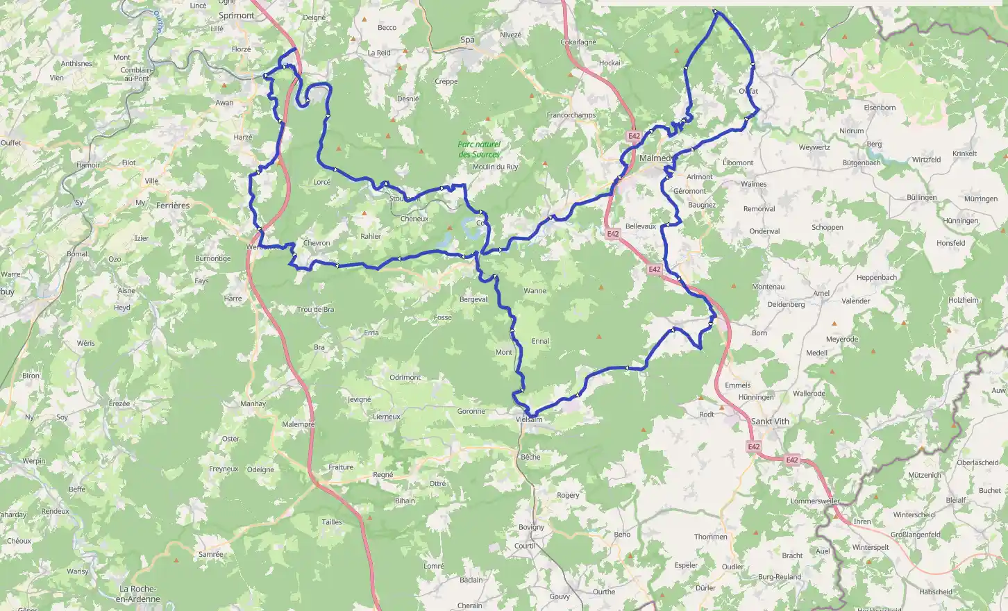
About the roof of Belgium
August 08, 2025

Aywaille, Liège, België / Belgique / Belgien
Easy
Description

No description for now...
Route
Start
356 m
Côte de La Redoute
50.49083, 5.70444The Côte de La Redoute is a climb, often included in the Liège–Bastogne–Liège cycle route. It is located in Wallonia in the municipality of Aywaille and its incline is 1.6 km long with an average of 9.5%. It is named after a redoubt in the battle of Sprimont, which occurred at the village of Fontin, which is located on it, in the municipality of Esneux. It also runs along an access route to autoroute E25 level with the town of Remouchamps. The region is the birthplace of cyclist Philippe Gilbert.
Author: Wikipedia
More information
439 m
La Redoute
50.49246, 5.69916Who doesn't know the Redoute? Perhaps the most famous climb in Belgium. The ascent has a length of 1650 meters. Not very long, but this is more than made up for by the gradient. At its steepest, the Redoute is 21%. Especially if you have some kilometers in your legs, it is enough reason to curse. Quite a nasty thing. The asphalt is chalked with names of pros who have passed by here. Of course you don't want to let yourself be known! And at the top, a beautiful view awaits you as a reward.
More information
2.33 km
Eglise Immaculée Conception
50.48270, 5.70535
Situated on the banks of the Amblève, encircled by an ancient graveyard with two fine chestnut trees in front of its porch, this church pleases those who appreciate rustic simplicity.
The first point to notice is its four sided Romanesque bell tower built in limestone (13th century).It is a listed building; one of the remnants of the ancient church. The present church, which is an extension of the tower, dates from 1744.
The interior is painted in white and is in the shape of a vessel with a single nave. It is illuminated by a dozen windows, some with stained glass and others just simple glass. The main altar is 18th century and recalls the Jesuit style. Some oak stalls in the choir. Louis XIV pulpit.
Author: Wizpr.guide
More information
2.33 km
La Casa Nostra
50.48197, 5.70743Cuisine: Italian
Budget: ± 30 Euro
Payment methods: American Express, Master Card, Visa, Bancontact
Closing days: Monday
Address: Rue du Halage 6, 4920 SOUGNE-REMOUCHAMPS
More information
2.72 km
Donna Maria
50.47983, 5.71194Cuisine: Italian, French
Budget: - 25 Euro
Payment methods: American Express, Diners Club, Master Card, Visa, Bancontact
Closing days: Wednesday (winter)
Address: rue Marcelin Lagarde 3, 4920 AYWAILLE
More information
2.72 km
Hotel Bonhome
50.47989, 5.71124Cuisine: French
Atmosphere: Contemporary surroundings
Group capacity: 40
Budget: ± 40 Euro
Payment methods: American Express, Master Card, Visa
Closing days: Wednesday, Thursday
Address: Rue de la Reffe 26, 4920 AYWAILLE
More information
2.77 km
Le Dragon Gourmet
50.47949, 5.71205Cuisine: Japanese
Budget: ± 30 Euro
Closing days: Monday noon - Tuesday noon
Address: Avenue Marcelin Lagarde 8, 4920 REMOUCHAMPS
More information
8.41 km
Ninglinspo
50.46875, 5.74689The Ninglinspo is a stream in Belgium, tributary of the Amblève upstream from Remouchamps around Quarreux. The valley of Ninglinspo is classed as an outstanding heritage area of Wallonia. It runs between Vert-Buisson and Nonceveux. The Ninglinspo forms rapids around enormous blocks of quartzite, forming a series of pools with evocative names.
Author: Wikipedia
More information
8.41 km
Ninglinspo
50.46877, 5.74559The curious name 'Ninglinspo' is the result of a spelling error by French cartographers who twisted quite a few place names in the 'Ourthe department' which was created here in 1876. They swapped the name of the stream with the name of the piece of land where the stream flows into the 'Amblève'. This piece of land was called: "En Inglin spau" i.e. at the source of Inglin, name of the person whose trace has been lost. The original name of the stream is in fact 'Le Doulneux' (in Latin: Dulnosus) which shows that it comes from an alder forest. In the charte of 'Sigebert III' from 647 this name is already mentioned.
More information
21.59 km
Chapel of Saint-Anna Stoumont
50.41016, 5.82654The chapel of Saint-Anne is listed on the list of monuments. The surrounding forest bears the same name. The chapel is not far from the Amblève and close to the road "Stoumont-La Gleize". The establishment of the chapel by the gentlemen of Froidcourt is ancient. Guillaume del Dyck and his wife Isabeau de Vervoz were said to have contributed to its construction in 1556. Through the centuries, the chapel has undergone a number of restorations and expansions. The ship was built on the site of the choir in 1666 (see date on the west facade). The chapel is built on a simple, rectangular plan and extended to the east by the choir. It is characterized by a hexagonal tower with a decorated cock-shaped windbreak, the rustic canopy that protects the vaulted gate and the believers who come to shelter in the chapel.A call to Saint Anna, made of copper by the parish priest Bolly of St. Denis, adorns the frontispice upon entry ("Saint Anne, with Your Holy Child, you want to be there for those who pray here the gate of heaven "). The interior is simple and has a flat roof with a single span. The choir consists of a rotated altar dating back to the late seventeenth century. Because of the late age at which his mother became his mother, St. Anna was called upon to fight infertility, for various diseases and even by young girls looking for a man. On the day of the feast of the saint there used to be a market. The chapel and its surroundings have inspired many artists, including Richard Heintz and Elysée Fabry. If you are a little curious, you can admire the castle of Froidcourt and its outbuildings (private property) along the road to Malmedy. This castle was built in 1913 on the site of old houses. The domain is the stronghold of the ancient feudal gentlemen of Froidcourt. From 1600 until just before the revolution, the estate was owned by De Lynden.
Author: Willem Vandenameele
More information
29.72 km
34.48 km
Hotel Restaurant O Mal Aime
50.39347, 5.92847Cuisine: French
Accommodations: Hotel
Budget: ± 40 Euro
Closing days: Monday, thuesday, wednesday. open on thursday noon, frieday, saturday evening and sunday.
Address: Rue Neuve 12, 4970 STAVELOT
More information
34.60 km
Pizzeria Figaro
50.39446, 5.92941Cuisine: Italian
Accommodations: Terrace
Budget: - 25 Euro
Payment methods: Diners Club, Master Card, Visa
Closing days: Open 7 days a week
Address: Place du Vinâve 4, 4970 STAVELOT
More information
34.71 km
Abbey of Stavelot
50.39407, 5.93150Bru is a sparkling mineral water used already in the seventeenth century by the monks of the abbey of Stavelot. They put in bottles and sold it as naturally carbonated sparkling water. Because of its lack of salt, Bru does not alter the taste of food. In the first century AD, Pliny the Elder was already talking about the mysterious sources of the Ardennes, probably also referring to this source.
More information
34.71 km
Hostellerie La Maison
50.39528, 5.92964Cuisine: French
Budget: ± 30 Euro
Payment methods: American Express, Master Card, Visa
Closing days: Monday - Tuesday noon
Address: Place Saint-Remacle 19, 4970 STAVELOT
More information
45.51 km
Ferme Libert
50.44663, 6.02722Ferme Libert
RouteYou Climb Code : D_1_b
- Length : 1.25 km
- Ascent : 143 m
- Average grade : 10 m / 100 m - 9.53 %
- Maximal grade : 18.01 %
Author: Cols&Climbs@RouteYou
More information
57.46 km
Fagne de la Poleûr
50.50993, 6.06977The Fagne de la Poleûr is located in the East Belgian municipalities of Weismes and Malmedy. The Polleur-Venn (La Fagne de la Poleûr) has been a scientific station of the University of Liège since 1924. With its 54 hectares, the Polleur-Venn shows the great diversity of the High Fens.
More information
58.91 km
Signal de Botrange
50.50235, 6.09264Signal de Botrange is the highest point in Belgium (694 meters above TAW). TAW is the Second General Leveling, the reference height system used in Belgium. In the Netherlands, the NAP (Normal Amsterdam Level) is used as a reference height system. Heights shown in the TAW are 2.33 metres lower than those shown in the NAP.
In 1804, the French colonel Tranchot built the first wooden tower for surveying measurements, which was later replaced by the current structures.
Author: haroldslegers
More information
59.00 km
Ardennes
50.50167, 6.09306The Ardennes ; Dutch: Ardennen [ɑrˈdɛnə] ; German: Ardennen; Walloon: Årdene [ɑːʀdɛn]; Luxembourgish: Ardennen [ɑʁˈdænən]), also known as the Ardennes Forest or Forest of Ardennes, is a region of extensive forests, rough terrain, rolling hills and ridges primarily in Belgium and Luxembourg, extending into Germany and France. Geologically, the range is a western extension of the Eifel; both were raised during the Givetian age of the Devonian , as were several other named ranges of the same greater range.
Author: Wikipedia
More information
59.98 km
Musée Fania - Maison Du Parc Botrange
50.49345, 6.09950Discover FANIA, our exhibition dedicated to the Hautes Fagnes!
It took a little more than a year to complete the transformation of the Museum of the Hautes Fagnes-Eifel Nature Park - Eifel. The concept has completely changed and the new design gives people the urge to explore the beautiful landscapes of the Fagnard Haut (High) Plateau.
In fact, at a couple of steps from the largest nature reserve of Belgium, FANIA is original, informative, interactive, fun, aesthetic and presents the Hautes Fagnes in all their states!
In short, what is on the menu at FANIA?
Throughout the exhibition, guided by a walkway, visitors discover the peculiarities of the climate of Hautes Fagnes, the relief and the soil composition, periglacial era and marks left etc.
But also, the natural landscapes, beech, oak, and birch woods with bogs, human action on natural environments and the origin of the moors, the protection and restoration of moorland etc.
To finish on a fun note, a sensory tunnel immerses the visitor in the sense of mystery of the Hautes Fagnes, listening to the birdsong in the morning, the sounds of the night, such as a fox inside a den, or climb, like a squirrel, in a nest made of branches.
Do you dare to experience thrills treading barefoot on mats of bark, spruce cones or peat?
-Museum/Interpretation centre
-Natural heritage
-Recognised nature park
Author: Fédération du Tourisme de la province de Liège
More information
62.00 km
High Fens Natural Park
50.47860, 6.11057Located in the east of Belgium, the Natuu park of the High Fens is the oldest in the country. This cross-border park is divided into 6 nature zones, 4 of which are in Wallonia. In the northwest lies the 'Avant-Pays Fagnard' with its dairy cows and forests. The nearby High Fens are a unique peatland in Europe. In the south lies the high Eifel with its wooded hills and the picturesque valley of the Our.
Author: Visit Wallonia
More information
65.49 km
The Robertville lake
50.45219, 6.10907The Robertville lake is in the nature park of the High Fens/Eifel, approximately 5 km north of Waimes. It has a surface area of 620,000 m², and with a depth of 54.5 meters at its deepest point, it has a volume of about 8 million cubic meters.Different activities can be enjoyed by the lake; for example fishing, mini-golf, canoeing or kayaking, cycling, tennis etc. In this beautiful environment, however, you can naturally also simply stop for a moment or two and enjoy the peace and picnic at one of the places set up for this. In addition to that, you are allowed to swim in the lake. The dam is built as an arch-gravity dam rising up 55 meters over the Warche valley. It was constructed in 1928 with the aim of supplying drinking water to the town of Malmedy and water to drive the power station in Bévercé.
Author: Wizpr.guide
More information
65.73 km
Reinhardstein Fortified Castle
50.45264, 6.10246Middle Ages Castle; unique in Belgium ! Majestic setting in the Hautes Fagnes.
-Museum/Interpretation centre
-Built heritage
-Castle
-Monument
-Historic site
-Natural heritage
-Panorama, viewpoint, scenery
Author: Fédération du Tourisme de la province de Liège
More information
65.73 km
Waterfall of Reinhardstein
50.45293, 6.10182The highest waterfall in Belgium is located next to Reinhardstein Castle. The waterfall plunges 60 meters deep into the valley of the Warche.
More information
65.77 km
Nose of Napoleon
50.45390, 6.09526The 'Nez Napoleon' or 'Nose of Napoleon' is a protruding steep rocky point that looks down on the valley of the Warche.
More information
98.55 km
Moulin Minguet-Ferme De La Reine Des Pres
50.29853, 5.96092Cuisine: French
Accommodations: Terrace
Budget: ± 30 Euro
Closing days: Open 7 days a week
Address: Route du Moulin 128, 6692 PETIT-THIER
More information
110.52 km
Rochelinval
50.34120, 5.89538Rochelinval had its place in the Battle of the Bulge. 250 members of the 551st Parachute Infantary Battalion were ordered on 7 January 1945 to attack the Belgium village of Rochelinval over open ground and without artillery support. During the successful assault the unit lost more than half its remaining men. Only 110 survived.
More information
123.38 km
La Levée
50.36803, 5.78399La Levée
RouteYou Climb Code : C_3_c
- Length : 4.86 km
- Ascent : 254 m
- Average grade : 5 m / 100 m - 5.21 %
- Maximal grade : 10.66 %
Author: Cols&Climbs@RouteYou
More information
133.10 km
Le Lucifer
50.38090, 5.68186Cuisine: Bistro
Budget: - 25 Euro
Closing days: Monday
Address: Route de Stavelot 1, 4190 WERBOMONT
More information
134.48 km
La Grille Hardie
50.39159, 5.67931Cuisine: Grill
Accommodations: Terrace
Budget: - 25 Euro
Closing days: Tuesday - Wednesday - Thursday
Address: Bosson 5A, 4190 WERBOMONT
More information
149.40 km
Finish